THAILAND
The poverty rate at the national level was 8.8% in 2020. However, there was no area-based data on poverty rates in Thailand. The number and density of retail outlets were provided as replacements in this section.
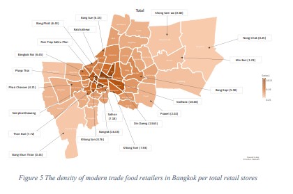
In terms of the density of food retailers, Thailand had a total area of 513,139.54 km2 per 66,558,935 population in 2019. The population density per unit area was 129.71 per km2. There were 14,178 modern food retail establishments. Therefore, the density of food retailers in Thailand was 0.03 establishments per km2. Bangkok had a total area of 1,568.70 km2 per 5,696,409 population. The population density per unit area was 3,631 people per km2. There were 3,951 modern food retail establishments. The density of food retailers was 2.52 stores per km2. Furthermore, in terms of the density of food retailers per Bangkok district, Pom Prap Sattru Phai district had the highest density at 18.13 establishments per km2 ), followed by Bang Rak District and Ratchathewi District (at 16.43 and 16.13 establishments per km2, respectively).
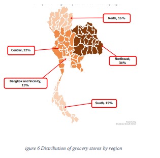
The total distribution of groceries by regions in Thailand in 2019 revealed that the distribution was highest in the Northeastern region (34%), followed by the central region (22%). The distribution was lowest in Bangkok and its vicinity (13%).
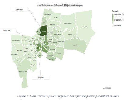
In 2019, the total income of registered stores based on district area totaled 226,172 cases, indicating that Chatuchak district had the highest total income of 4,941,995.29 million baht, followed by Bang Rak and Pathumwan (2,445,600.81 million baht and 1,963,648.79 million baht, respectively).
As for the final result, Chatuchak district was systematically selected as a study site for data collection.